Looking for multi-purpose GPS - for Land and Sea

SailorDon

Well-known member
I'm looking for an upgrade replacement GPS for driving, boating, and sometimes hiking.

I've sort of got the driving covered with the Ford NavSYNC that came with my 2010 F-150 pickup truck. But the database for the NavSYNC GPS navigation is 5 years old and Ford wants me to pay $200 per year for an update.
By not updating, I have saved $800. That should buy a pretty good portable GPS with current navigation database!

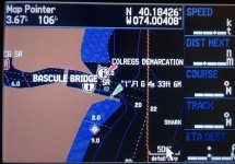
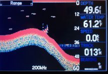
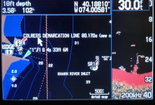
The boating GPS requirement is for my Thames Rowing Skiff. For rowing, I am using an 11 years old Garmin Zumo 550 motorcycle GPS. It is falling apart, held together with tape, and the motorcycle format isn't the best for rowing. (Who needs a fuel gauge on their GPS when rowing or hiking?)

I've searched the internet and found the Garmin Montana 650. It has the nice added feature of a built-in digital camera.
Does anyone have experience with the Garmin Montana 650? User reviews on the internet indicate the software isn't reliable and causes GPS lock-ups, loss of data, etc.

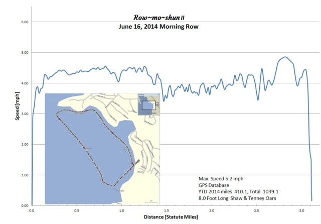
At the end of each rowing adventure, I download my GPS data to my computer and prepare a summary chart similar to the one below for today's rowing on Lake Livingston.


I can't tell if the Garmin Montana 650 has proximity alarms, like when approaching a known danger item, like a tree stump or rock in the lake, or a low clearance overpass on the highway.
.
 

olcoon

Well-known member
I kind of think you are going to have a hard time finding one GPS for all of those activities. Personally, I'm a big Garmin fan, however I haven't owned anything but Garmin. However talking to several people who have other brands, I'm going to stick with Garmin. That said, Garmin has the RV760LMT for RVing that I've heard good reviews on, one of the club members has one, and has had good luck with it. Here is a link to the thread. I'm seriously thinking about replacing our Nuvi with one when it dies. I've thought about replacing my 10+ year old hand held with the GPSMAP 64ST, here is a link to Garmin's website for it. I don't know how it would be for boating, I would mainly use it for hiking, hunting, etc. From what I've heard from people that own the Rand McNally GPS for RVing stay away from it, it would make a fair rock to throw at a rat, but that's about all.
 

SailorDon

Well-known member
I purchased a Garmin Montana 650 GPS. It is expensive, but it includes a built in digital camera among it's many features.

I haven't used it for road navigation since I have NavSync in my 2010 Ford F150 tow vehicle. I'm sure the Montana 650 could be used for road navigation including voice instructions, but the 4" display screen is more suitable for hand-held navigation than for RV or vehicle navigation.

For those that go beyond the limits of street navigation (off-road or offshore), the user can upload Custom Maps that are displayed on the navigation screen. (Custom Map requires use of Google Earth for correct alignment with GPS location.) Works great on topographic maps. My specific application is navigation on lakes. I bought Garmin LakeVu which includes details of 17,000 lakes in the USA.

There are some minor "bugs" such as:
Screen capture doesn't work unless backlight is on.
When Map is displayed and you enter into a Proximity Alarm area, the screen goes to white, the map goes away, and a warning that you are entering the Proximity Area is displayed.
For example:


When you use the "GO HOME" command on the main menu, and you are not on a NavTech documented road, you get the following useless message.


In addition, all the custom Profile information defaults back to a Nuvii format. This is a royal PITA and I have done my best to disable the GO HOME feature by "hiding it".

Summary, the Montana 650 does most of what I want from a GPS, and a little bit more.
.
 

porthole

Retired
Probably overkill for your rowing, but a Garmin GPS 478, if you can find one.
https://buy.garmin.com/en-US/US/on-the-water/discontinued/gpsmap-478/prod402.html

I use mine for the truck, motorcycle and boat. If I was hiking deep into the woods or biking well off a beaten trail, I would bring it along as well. When boating a simple button push changes the US road maps to an electronic chart plotter with all the aids to navigation that you would expect to see.

Decent battery life, waterproof and multiple mounts available.

Also has the capability to add a color video depth sounder to the display and Garmin XM weather allows an overlay or real time NEXRAD RADAR and weather. XM radio can be added as well.
 

happyappy

Active Member
When it comes to multipurpose, I love my smartphone. There are apps available to handle all the GPS requirements you mentioned.

Here's one that would track your rowing

I find Google to be a great navigation system. But if you are traveling in areas with no cell coverage, here's an app that allows you to download maps and continue using your smartphone as your GPS.

CoPilot Navigation

These links are to android apps, but I'm sure there are similar apps for Apple if you are an Apple fan.

Hope this helps in your search.
 

SailorDon

Well-known member
Probably overkill for your rowing, ..................
The addition of a color video depth sounder is way out of my league for a Thames Rowing Skiff.
478 screen is small 3" compared to 4" for the Montana 650
478 has a bunch of control buttons. Montana 650 is controlled from touch screen menus (except for one 0n/Off button).
......I only mention this because all the rubber buttons on my Garmin Zumo 550 popped out when the rubber deteriorated in the sun. $150 for Garmin to replace 5 buttons at 5 cents each. Customer rip off.
478 has Garmin battery. Montana 650 has rechargeable Garmin battery or AA Penlight batteries. 13 hours battery life (but not with backlight on - the backlight is a power hog).
With the Montana 650 you can add your own Custom Maps. 'g2' isn't going to have a chart of Lake Bastrop for your Garmin 478. I don't think it's going to happen.
With the Montana 650 see my Custom Map install for Lake Bastrop at (skip to 1m 15s for the good GPS stuff).

In summary, the 478 would be overkill in add-on features I would never use, and missing some features that are on the Montana 650 that are nice to have.
.
 

SailorDon

Well-known member
When it comes to multipurpose, I love my smartphone.

I've seen a smart phone, but I don't have one. My cell phone is so old, it doesn't even do text messages. :(

This could be a good thing because the NSA, CIA, etc., doesn't know where I am! :cool:
.
 

porthole

Retired
Hey I didn't say it was perfect :rolleyes: and it is a bit of an old school GPS. You referenced a zumo 550, which is why I brought it up. I had a Garmin 276C, upgraded to the 478 when it came out. I was given a zumo 550 to demo and really disliked it. Gave it away.


And if I got it right, Lake Bastrop is in Colorado, since I don't have the west downloaded onto my GPS I can't look to see what detail there is.
I haven't downloaded any G2 charts, don't know if I can. But, any navigable waterway that has paper charts and ATON's I have on my GPS.

Not looking forward to when my 478 dies, the replacements (478's) are out there and go for about the new price.
 

SailorDon

Well-known member
But, any navigable waterway that has paper charts and ATON's I have on my GPS.

I'm not sure about paper charts and ATON's (what's an ATON?) but the upgrade for the Garmin lakes database is LakeVu HD. That's about as good as it gets for Garmin.
$150 for 17,000 lakes per Garmin advertisement. Plug-in SD card.
For Lake Bastrop, Texas, this is what you get with LakeVu:


What you get with the basic map in the Montana 650 is a blue blob with virtually no shoreline detail.

I searched the internet for Lake Bastrop maps and found a detaiedl PDF image. I translated that to .jpg and uploaded to the Montana 650 Custom Map folder.
The result is:


By zooming in on the GPS display, every depth contour line can be read.
Chances are the only place you will get this kind of detail for Lake Bastrop is from the Lower Colorado River Authority.

The lake is navigable and about 2.5 miles long.
The lake has two camping areas that are very nice with several pull through campsites.
I was the only Heartland travel trailer in the North Camping Area.

.
 

porthole

Retired
For Lake Bastrop, Texas, this is what you get with LakeVu:


What you get with the basic map in the Montana 650 is a blue blob with virtually no shoreline detail.

I searched the internet for Lake Bastrop maps and found a detaiedl PDF image. I translated that to .jpg and uploaded to the Montana 650 Custom Map folder.
The result is:


I get the same view you show here in either the roads or marine version for lakes that are not charted. And, there is no custom map folder. Heck, I can't even download a POI file.

But, if there is a paper chart I probably have the marine chart already on the 478. Although of no use to you, the video bottom recorder is a pretty cool feature that only requires a transducer to work.
The first screen shot is the inlet near our house, Shark River Inlet - Atlantic ocean
 

Attachments

  • Garmin_1.jpg
    Garmin_1.jpg
    341.5 KB · Views: 14
  • Garmin_2.jpg
    Garmin_2.jpg
    285.4 KB · Views: 9
  • Garmin_3.jpg
    Garmin_3.jpg
    283.8 KB · Views: 10

Steadfast

Active Member
I am not saying that it is perfect for your needs, but with the Garmin 650T, you can download satellite imagery and display it on the GPS. You could grab the image of the whole lake of just a portion. The cost for the imagery is about $30 per year.
 

SailorDon

Well-known member
I am not saying that it is perfect for your needs, but with the Garmin 650T, you can download satellite imagery and display it on the GPS. You could grab the image of the whole lake of just a portion. The cost for the imagery is about $30 per year.
Maybe I'm missing something about the features of satellite imagery. Some key navigation items are missing, like roads in dense woods and water depth when boating .

How is the satellite imagery (at $30 per year) different than Google Earth?

I'm planning a camping/boating trip to Bowman's Lake, MT next summer.
Here is Google Earth, showing lake, shoreline and campground.


Here is Garmin Montana 650 with LakeVu HD maps loaded into memory.


Notice the addition of the water depth in the Garmin LakeVu HD.

I still have an unanswered question about being able to trailer my 2014 Heartland Wilderness 2175 RB to the Boman's Lake campground. The best information I can find is that the road to the campground is 9 miles of 1 lane gravel road. I don't think satellite imagery is going to help me figure out if I can get to the campground without breaking an axle.
 

porthole

Retired
I still have an unanswered question about being able to trailer my 2014 Heartland Wilderness 2175 RB to the Boman's Lake campground. The best information I can find is that the road to the campground is 9 miles of 1 lane gravel road. I don't think satellite imagery is going to help me figure out if I can get to the campground without breaking an axle.


I don't know about the area you are going to, but I frequently use this site to scan campgrounds.
http://www.bing.com/maps/

At least on the east coast there are a lot of images available on this site.
Three views are offered for many locations

A standard computer type road map
An aerial view, which is your typical google earth type SAT view, loaded with leafed trees. But, the images are different from google earth.

And a "Birds's Eye view. These are for the most part, aircraft taken photos, and at least in our area after the leaves have fallen. Besides being able to zoom in tight, there will typically be a "4 points" view. Angled downward from the north, south, east and west.

Sometimes the different views are taken on the same overflight, and sometimes not. Our house currently looks like all four views are on the same day. But in the past we could tell by the cars in the driveway that the 4 views were spread over a year.


Give it a try and check your lakeside campground.
 
Top